The Anthropocene Epoch is a novel, yet unofficial, unit of geologic time, used to describe the most recent period in Earth’s history when human activity started to have a significant impact on the planet’s climate and ecosystems. The Anthropocene is also a period characterized by an unprecedented technology level that allows us to measure essential variables of the climate system (ECVs) at high temporal resolution (e.g. satellites) and forecast future climate scenarios using state-of-the-art supercomputers based on Shared Socioeconomic Pathways (SSPs). However, instrumental records exist only since the mid XX century while simulations are time-limited to a few centuries. Thus, it remains elusive whether the documented and predicted changes are part of the long-term natural variability of the climate system. In this respect, climate archives such as ice cores, marine/lake sediment cores, corals, speleothems and tree-rings offer an extraordinary perspective of the past climate evolution and, thus, they represent a fundamental benchmark to place on-going climate change into a larger context of long-term natural climate variability. In particular, the past climate is punctuated by important climate events that can be used as examples (not necessarily analogues) to assess the rate of natural changes and understand the interactions between critical components of the climate system including external and internal forcings. Thus, paleo-climatology is a fundamental research field for the study of the Anthropocene as it provides insight into how Earth's climate system works and how it may change in the future. This, ultimately, improves climate models by lowering uncertainties on future projections.
Natural archives of past climate history are pillars for paleoclimatologists as they literally represent time machines. Scientists look for clues of past events in these records as biological, geochemical, and sedimentary indicators used for the empirical quantification of climatic and environmental parameters, something generally referred to as proxies. Each type of archive comes with its benefits and drawbacks. Thus, paleo-studies greatly benefit from the integration of complementary archives together to have an interdisciplinary overview on how the climate system works.
Main ERC Panels:
• PE4_5 - Analytical chemistry
• PE4_18 - Environment chemistry
• PE10_1 - Atmospheric chemistry, atmospheric composition, air pollution
• PE10_3 - Climatology and climate change
• PE10_6 - Palaeoclimatology, palaeoecology
• PE10_8 - Oceanography (physical, chemical, biological, geological)
• PE10_9 - Biogeochemistry, biogeochemical cycles, environmental chemistry
• PE10_11 - Geochemistry, cosmochemistry, crystal chemistry, isotope geochemistry, thermodynamics
• PE10_18 - Cryosphere, dynamics of snow and ice cover, sea ice, permafrosts and ice sheets
Referents: Andrea Spolaor, Tommaso Tesi
Contact: info-paleoclimate AT isp.cnr.it
Sub-themes
Ice cores
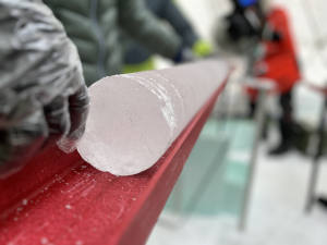 Ice cores are among the best resolved archives of the past Earth climate to the point that it is possible to describe even seasonal climate oscillations. They are drilled on mountain glaciers and ice sheets, where year-round below freezing temperatures allow undisturbed solid deposition and preservation of the original stratigraphy. Ice cores recovered from Antarctica and Greenland provide the oldest records, covering respectively the last 800 000 and 125 000 years. Yet, important climate information can also be extracted from non-polar glaciers such in the Alpine, Andes and the Himalaya regions. Among the climatic information, ice core analyses can give insight to past temperatures, volcanism, winds, precipitation, aridity, solar activity, change in biogeochemical cycle and atmospheric composition. In particular, ice core records are valuable paleo archives for the past atmospheric composition since the ice can trap the chemical compounds and their abundance as well as the gasses concentration, preserved in the ice as air bubbles of an ancient atmosphere. Physical properties of the ice layers identified in the core can also be studied and provide the past history of ice sheet dynamics.
Sediment cores
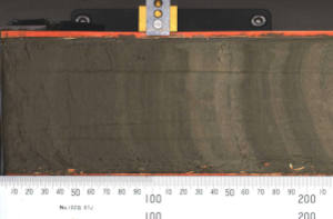 Marine sediment records can span millions of years, with the resolution that can vary from centuries to seasonal deposition and thus they represent far the oldest climate archives available. Sediments cover all latitudes meaning that they can provide information about different environmental conditions and, thus, can resolve different aspects of the climate system from the Equator to Polar Regions. Lake sediments are complementary to marine archives as they provide information about the terrestrial environment although their temporal range is usually much narrower. There is a wide range of proxies that can be analyzed in sediments to describe several Essential Climate Variables (ECVs) during different periods of the Earth’s history. The most common ECVs studied through sediments include, among the others, surface ocean and atmospheric temperature, salinity, sea ice distribution and ice-sheet dynamics, precipitation on land, dissolved oxygen content, sea level change, ocean current energy, ocean pH, nutrient availability and primary productivity. Overall, proxies analyzed in sediments can be grouped into three main categories: sedimentological, geochemical and ecological parameters. Sedimentological proxies typically provide information about the paleo-depositional environment that changes over different climate conditions. Geochemical proxies embrace a wide number of organic molecules and inorganic elements including their isotopes and reflect an extensive range of biotic and abiotic processes all driven by climate. Finally, ecological proxies are mostly fossils (e.g. diatoms, foraminifera) whose original community structure varies as a function of the paleo-climate conditions.
Corals
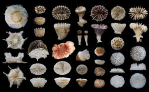 Cold-water corals (CWC) are widely distributed to great depths (from the intertidal to more than 4000 m) in all ocean basins, and occur as massif coral reefs, coral carbonate mounds, or coral patches. CWC are one of the few organisms that can calcify within corrosive undersaturated environments, common to the very cold depths of the high latitudes in the Southern Ocean waters (including Antarctica) and North Atlantic. CWC have unique advantages compared to other established sedimentary archives: 1) they can be radiometrically dated using both 14C and U-series and techniques; the latter to better than 1% accuracy, 2) they incorporate trace elements, stable and radiogenic isotopes reflecting seawater temperature, nutrient content, pH and dissolved inorganic carbon, ventilation age and water mass provenance and 3) their relatively massive size allows multiple proxies to be applied within a single individual specimen.
 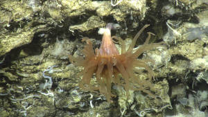 Furthermore, their slow growth rate (~ 0.1 mm/yr) and long life spans (~ 100-200 yr) enable quantifying sub-decadal scale oceanic variability at a range of depths in the subsurface ocean for century-long time slices through much of the last glacial period and deglaciation. Therefore, CWC has the potential to reconstruct key physico-chemical parameters of the high latitude North Atlantic and Southern Ocean and reveal critical aspects of the recent warming in the Arctic and Antarctica in relation to the climate-ocean dynamics (e.g. changes of AMOC and ACC) and the major modes of atmospheric variability at decadal timescale.
Speleothems
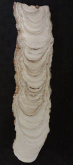 Speleothems, and in particular stalagmites, are a widely used paleoclimate archive given that they can grow continuously for thousands of years, resist alteration, be precisely dated, and provide high resolution paleoenvironmental information. Karstic cave environments are present worldwide at all latitudes and can thus provide complementary records to marine sediments and ice cores, at comparable resolutions and times scales (>500 kyr BP), and with an ability to preserve multiple independent climate proxies of local to regional processes at orbital to seasonal scale. The chemical composition of speleothems is determined by the composition of cave drip water, which in turn is influenced by temperature, precipitation, vegetation composition, and environmental changes occurring over the cave. Stable isotopes of oxygen and carbon, along with trace elements, are the primary well-established chemical markers used in speleothems for the reconstruction of long-term changes and patterns of periodic and abrupt climate oscillations affecting atmospheric and oceanic circulation. In addition, a newly developing field of research is showing the potential of trace organic compounds in speleothems for high-resolution reconstruction of fine-scale features such as paleofire frequency.
Glacier geomorphology
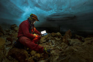 Glaciers release a vast set of geomorphological features able to maintain the memory of past glaciations and colder climate periods. As such, they are a useful paleoclimate proxy of past cold phases when conditions were more favorable to glaciation. Reconstructing the extent of paleoglaciers allows calculations on past glacier geometry, ice volume and thus the climate. In fact, the existence and dimensions of terrestrially terminating glaciers is controlled, to a first order, by climate, through variations in temperature and precipitation. When the geometry of a paleo glacier is inferred from geomorphological evidence, the ratio between the glacier accumulation area and the entire area of the glacier, which is called Accumulation Area Ratio (AAR) and is somewhat well known for different types of glaciers around the globe, allows calculation of the effective Equilibrium Line Altitude (effELA) of that glacier. The ELA joins points on a glacier where annual accumulation exactly balance annual ablation and therefore the sector of the glacier where the annual mass balance equal to zero. From this information, using empirical models and environmental lapse rate, is possible to infer the climatic conditions when that particular glacier was in equilibrium with the climate. The ELA can be modeled following an inverse approach based on bias corrected annual precipitation and summer temperature, considering the glacier at a steady-state during the simulation. The so-calculated ELA is defined as the Environmentla ELA (envELA and represents the lowest boundary of the climatic glaciation. Eventually, areas where the envELA is lower than the topography indicate conditions supporting the existence of glaciers, supporting geological and geomorphological evidence on the ground. Such a procedure is useful for both paleoglaciers extension and future scenarios.
 Ice cores are among the best resolved archives of the past Earth climate to the point that it is possible to describe even seasonal climate oscillations. They are drilled on mountain glaciers and ice sheets, where year-round below freezing temperatures allow undisturbed solid deposition and preservation of the original stratigraphy. Ice cores recovered from Antarctica and Greenland provide the oldest records, covering respectively the last 800 000 and 125 000 years. Yet, important climate information can also be extracted from non-polar glaciers such in the Alpine, Andes and the Himalaya regions. Among the climatic information, ice core analyses can give insight to past temperatures, volcanism, winds, precipitation, aridity, solar activity, change in biogeochemical cycle and atmospheric composition. In particular, ice core records are valuable paleo archives for the past atmospheric composition since the ice can trap the chemical compounds and their abundance as well as the gasses concentration, preserved in the ice as air bubbles of an ancient atmosphere. Physical properties of the ice layers identified in the core can also be studied and provide the past history of ice sheet dynamics.


