MDI
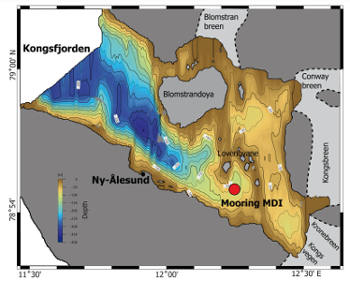
 A permanent instrumented mooring has been installed in the inner part of Kongsfjorden (Svalbard Islands) at a depth of about 100 m with the aim of studying the intensity and composition of the flows of particles falling to the sea bottom, while monitoring the main physical properties of the water column. The mooring called Dirigibile Italia (MDI) was first installed in September 2010 and is serviced annually. The data acquired and stored by the various instruments are downloaded during maintenance, checked for QA/QC and uploaded to the Italian Article Data Center (IADC).
A 10-year time series of data for climate purposes is currently available.
 MDI allows us to continuously monitor the variations of the thermohaline characteristics of:
a) surface water from glacier melting;
b) intermediate water that derives from the intrusion of Atlantic-type water;
c) bottom water produced locally during the winter.
Furthermore, through the collection of particulate matter, information is acquired on sedimentary processes and interactions between water and particulate matter with microzooplankton, glaciers and coastal runoff. The complex interplay between the processes that drive the input of native (marine) and alien (terrestrial) particles into Kongsfjorden has now been understood, some interpretations of possible future changes in particle flows for Arctic fjords in a warming scenario global can be suggested.
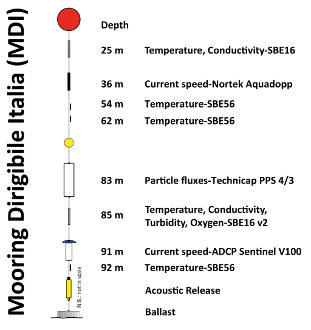
 The oceanographic sensors on MDI are positioned along the mooring at different levels in the water column. The list of measured parameters includes:
- water temperature at 25, 36, 54, 62, 85 and 92 m
- speed and direction of currents at 37 and 93 m
- conductivity / salinity at 25 and 85 m
- turbidity and dissolved oxygen at 85 m
- total mass and particulate organic carbon flows at 83 m.
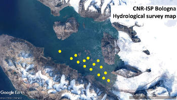
A hydrological survey is also performed every year, mainly during the summer, to obtain a seasonal picture of the spatial distribution of the different water masses in the fjord. For this purpose, a grid of about 15 stations is repeatedly measured for the main chemical-physical characteristics of the water masses: temperature, conductivity and turbidity.
MS1 and ID2
The water masses in the eastern Fram Strait are strongly influenced by the interaction between the Atlantic and Arctic waters, and by local atmospheric forcing. They clearly contribute to driving thermohaline circulation on a global scale. There is considerable variability in the system due to the different forcings (for example, atmospheric, internal, tidal, shelf dynamics) that play an important role, especially in the most superficial layer of the ocean. On the contrary, it is not entirely clear which processes are responsible for the inter-annual and seasonal variability of the deep flow in the western Spitsbergen offshore region.
To this end, in 2014 the oceanographic deep-sea mooring called MS1 was permanently installed, located southwest of Svalbard at about 1040 m depth (Lat. 76° 26.28'N Lon. 13° 56.91'E) in a joint effort between CNR and OGS. Long-term time series are essential for studying climate change, particularly in polar areas, which are extremely sensitive to global warming and sea / land ice melt. A twin mooring, called ID2, was placed 140 km north of anchor MS1 at approximately the same water depth in the years 2014-2016 and 2017-2018, in order to monitor spatial differences of in the properties and dynamics of the water along the Spitsbergen margin.
These undersea infrastructures represent the continuation of the experiment conducted in 2010-2011 as part of the EU-Hermione project with the launching of four moorings for one year along the Storfjorden continental slope to monitor the shelf-fjord exchanges and the platform dense water cascading events.
The MS1 and ID2 mooring are serviced annually by various research vessels (R/V Helmer Hansen, GO SARS, Polarstern, Alliance), and are supported by international collaborations and numerous projects/initiatives: EU-Eurofleets (PREPARED, BURSTER projects), the Italian PNRA program (DEFROST project). Since 2017, they are also supported by the IIM HIGH NORTH Italian Navy program managed by the Hydrographic Institute of the Navy (IIM) in collaboration with the Center for Maritime Research and Experimentation (CMRE-NATO).
Data from MS1 and ID2 were used to contribute to the first two issues of The State of Environmental Science in Svalbard - an annual report (SESS Report) published by SIOS (Svalbard Integrated Observing System) in 2018 and 2019 (SOA project). Mooring data are downloaded in delayed mode during mooring maintenance, checked for QA/QC and stored in the OGS NODC data center with connection to SeaDataNet. At present, the data on temperature, salinity, dissolved oxygen, turbidity and horizontal currents cover a time period from June 2014 to October 2019. Information on sedimentary processes and interactions with mesozooplankton, glaciers and coastal runoff are acquired by collecting the particulate that sinks along the water column using automatic sediment traps.
Oceanographic sensors are tied to different levels in the deepest part of the water column. The list of parameters measured in the MS1 anchoring in its most recent configuration (v2019) includes:
- water temperature at 894, 909, 984, 1009 and 1115 m
- speed and direction of currents at 909, 984 and 1015 m
- conductivity/salinity and dissolved oxygen at 1009 m
- total mass and particulate organic carbon fluxes at 1009 m.
The time series of temperature and salinity are checked by comparing them with the data of the CTD drops performed before and after maintenance of the mooring.
The main institutions involved are: CNR with CNR-ISP and CNR-ISMAR, OGS and IIM.
 A permanent instrumented mooring has been installed in the inner part of Kongsfjorden (Svalbard Islands) at a depth of about 100 m with the aim of studying the intensity and composition of the flows of particles falling to the sea bottom, while monitoring the main physical properties of the water column. The mooring called Dirigibile Italia (MDI) was first installed in September 2010 and is serviced annually. The data acquired and stored by the various instruments are downloaded during maintenance, checked for QA/QC and uploaded to the Italian Article Data Center (IADC).
  MDI allows us to continuously monitor the variations of the thermohaline characteristics of:
  The oceanographic sensors on MDI are positioned along the mooring at different levels in the water column. The list of measured parameters includes: